Sunday, 16 April 2017

QATAR


This hot, desert country juts out from the east coast of the Arabian Peninsula into the Arabian Gulf. It has Bahrain to the west and United Arab Emirates to the south-east.


The country measures an area of 11,435 sq km, has a population of 435,000 people and its capital is Doha. Languages are spoken Arabic and English. The religion is Muslim

Qatar is flat and barren and the highest point is 75m. There is little natural vegetation and only patches of scrub. It has not a lot of wildlife but only dangerous desert creatures such as camel spiders and scorpions.

Birdlife, including falcons, is common.

ECONOMIC

Qatar was a poor country and the only income was pearl diving as a main industry.
PEARL QATAR


In 1939 oil was discovered and it boosted the economy greatly. Ever since the standard of living improved and many foreign workers came to Qatar.

Natural gas is also an important source of income and the North Field is one of the largest natural gas fields in the world.


HISTORY

Qatar’s main history was only civil ones and it was between the Al-Thani family who ruled Qatar since the mid-18th century and the Al-Khalifa family. The Al-Khalifa family rules Bahrain and originally occupied Zubara, north Qatar.

In 1932 the Al-Thani reclaimed Zubara and the western peninsula. There is still a dispute over the Hawar islands, on the west coast.

In 1971 Qatar became independent from Britain.

The country’s Emir, ruler of the country, is Khalifa Bin Hamad Al-Thani.

In 1989 Qatar opened its doors to tourism.

The Zubara fort, near the north-western coast, was built in 1938 when the Al-Thani family claimed Zubara from the Al-Khalifa’s of Bahrain.

The fort was built as a border police post and used by the military until the mid-1980s. It was for many years the main settlement in Qatar, but now it is a museum.


SAUDI ARABIA


It is an area of approximately 2,500 sq km and a population of 16.9 million. The capital is Riyadh.

Saudi Arabia is the cradle of the Islamic religion and one of the richest countries in the world. It has 25 per cent of the world’s oil reserve. Saudi Arabia is a powerful force in the Middle East.

It is a huge country and occupies most of the Arabian Peninsula; borders in the north on Jordan, Iraq, Kuwait. In the east on United Arab Emirates and Qatar and on Oman and Yemen in the south.

The country is mostly mountainous or desert and has no rivers or water courses.

Temperatures can reach 54C at midday and drop to below freezing at night.

AGRICULTURE
The tough climate limits farming and only around oases and on terraced hillside farming is possible. Some villages still use ancient irrigation methods but since the 1980s agriculture has improved dramatically.

Most of the areas irrigated are circular for the rotating sprinklers can water the whole area easily.

Fossil water used for irrigation in some regions is 17,000 years old. Desalinated sea-water is also used.

Modern irrigation systems using desalinated or fossil water, combined with the use of pesticides, drought-resistant crops and new farming methods, such as hydroponic, made Saudi Arabia a major exporter of wheat. Alfalfa, maize and barley are also grown on a large scale. Vegetables, dates and fruit are still grown on small farms.

Saudi Arabia imports sheep but raises its own dairy animals. Mutton is the country’s main dish. Fish come from the Arabian Gulf. The great export of shrimps to the US and Japan was destroyed by the oil pollution caused in the 1991 Gulf War.
CULTURE
Religion and politics are the same. It is the Muslim holy land. The country holds Islam’s two holy cities. Mecca is the birthplace of the prophet Muhammed and Medina his burial place.

The country has an Islamic monarchy, which means that the king combines his role as Custodian of the Two Holy Places and religious leader, or imam, and being both king and prime minister.

The two deputy prime ministers and heads of the armed force are also members of the royal families.

The population is mostly Sunni Muslims and practice their religion very strictly. Men and women live separate lives, even at home. Women must be veiled in public and are not allowed to drive.

The Islamic Law of the country is very strict. People are flogged in public for drinking alcohol, hands cut off for theft and punishment for adultery is death by stoning. The religious police force, matawwa, enforces the rules.

Shortly after the state was created by the first king, Abdul Aziz Ibn Saud in 1932 oil was discovered. It is now the biggest oil exporter in crude and refined oil.

The country has also huge reserves of natural gas.

The country has used huge sums to modernize the country such as roads. airports, hospitals, schools, housing, water supplies and telecommunications.

The people enjoy a very high standard of living and most of the services are free or very cheap.
WILDLIFE
Saudi Arabia has a big wildlife out in the country with gazelle, wild cats, snakes, scorpions, wolves and mongooses. The sea snakes in the Gulf are deadly. One drop of their venom can kill five adults. Millions of migrating birds pass over the country each year.

Two traditional forms of hunting are popular, Falconry and coursing which uses the swift and beautiful Arabian hunting dog. the saluki.  

Oil money has also been used to conserve wildlife and repair the terrible  damage by oil pollution from the Gulf War. Today there are 56 wildlife reserves and 52 areas of marine conservation.

KUWAIT


Till Iraqi invasion, in 1990, the tiny state of Kuwait lived an obscure oil sheikhdom. From that moment on it was in the eye of the world but recovered from the disastrous invasion.

Kuwait has an area of 24,280 km, a population of 1,5 million and Arabic and English is spoken.

It is bordered by Iraq and Saudi Arabia. Kuwait is at the north-western edge of the Arabian Gulf.

In summer, temperature can reach 50C and in winter drops to a low as minus 6C. Rainfall varies from 22mm to 352mm per year. Dust storms can reduce visibility to zero.

Kuwait City had been started about 300 years ago by members of the Utbi tribe. They came from central Arabia driven out by drought. They build a fortified camp named Kuwait meaning ‘small fort’. The ruling Al-Sabah family have been in power since 1752.
Kuwait City was gradually built around its fine natural harbour. Today the city and the country’s economy are being rebuilt after the devastation caused by the Gulf War in 1991.
ECONOMY
Before the discovery of oil, Kuwait’s asset was its fine natural harbour which made it a good stopping-over place for traders. The country’s income came from camel caravans, and fishing, especially for pearls. 
Agricultural land was and is non-existent, although some wheat and vegetables are grown near the Saudi Arabian border. 
The land is mostly desert and the wildlife there was – lizards, snakes and small mammals, plus flamingos, steppe eagles, cormorants and bee-eaters – were largely destroyed by the Iraq’s invasion and have not fully recovered since.

In 1930 Kuwait sunk the first oil well and it has discovered that the whole area is floating on a sea of oil.

By 1950 Kuwait was becoming enormously rich. The government spent huge sums on education, health care, building and industrial development, roads and communications.

Because of the small native population, the government encouraged foreign workers into the country but they soon outnumbered Kuwaitis.

Iraq’s invasion in 1991 was the biggest disaster in Kuwait. Allies made all the effort to get the Iraqi army out but on their retreat, they caused enormous destruction to Kuwait City and the industries. They torched most of the oil-wells which caused massive economic and ecological damage.

Kuwait and its people are steadily recovering from the war but the evidence Iraq left behind is still there. There are mines littering along the coastline, in the sea and desert.


Friday, 7 April 2017

IRAQ


The modern state of Iraq lies in the so-called “cradle of civilization”, the valley of the Tigris and Euphrates rivers.


Like most of the Middle eastern countries, modern Iraq was carved out of the old Ottoman Empire at its collapse in 1918.

It is on the border of Turkey, Syria, Jordan, Saudi Arabia. Kuwait and Iran.

Iraq has two outlets to the Arabian Gulf, the river port and large city of Basra and Umm Qasr near the Kuwait Border.


The country climate is harsh. Summer temperatures reaching 40C and cold hard winters, with rain in northern areas and snow in the mountains of the North-east. A dry north-west wind, the shamal, brings frequent summer sandstorms.

AGRICULTURE

Between the arid desert of the west and the mountains of the north-west, Iraq has much fertile agricultural land. Barrages and dams on the Euphrates and Tigris rivers, north of the cities of Hit and Samara create a well-watered upper plain. The main crops are wheat, barley and maize. The lower plain, south of Hit and Samara to the Gulf, is a marshy land where rice is grown. Along the River Shatt al-Arab dates are grown. Iraq produces 80 per cent of the world supply.

In the foothills of the mountains in the north-east tobacco, fruit, tomatoes and grapes are grown. Sheep and cattle are reared to export wool and meat.

Iraq is rich on natural gas and oil and has 15 per cent of the world’s reserves of oil. Due to its natural resources and major agriculture Iraq could be a great country in the Middle East, if not the greatest.

PEOPLE AND HISTORY

The land between the Tigris and Euphrates was formerly known as Mesopotamia. It there that the first civilization, the Sumerian, developed around 4000 BC.

The Sumerians were followed by the Babylonians, the Assyrians and the Persian Sassanians.

Muslim Arabs first arrived in 637 AD. The country came back to its former glory under the Muslim Abbasid dynasty, who claimed descent from Mohammed’s uncle and created a new capital Baghdad.

The last Abbasid Caliph was murdered by the Turks in 1258. From that date until the end of the World War I the area was part of the Ottoman Empire.

After 1921 Iraq was a kingdom under British protection, gaining full independence in 1932.
1958 the king was overthrown and a republic was set up. Coup after coup until a real stability came into power under army Commander, Saddam Hussein. During the stable climate of 1970 the country started to progress rapidly as a major oil producer.

Iraq’s problems are that the Muslim’s population is divided into Shiites and Sunnis but the ruling party are Sunnis who fear the Shiite Muslims especially from neighbouring countries such as Iran.

Another problem is the mountainous region in the north-east of the country is home of four million Kurds. Kurds are an ancient people whose native land was included into the Ottoman Empire.  When the empire broke up they were promised an independent homeland but it never happened. Nowadays the Kurds are a large minority in Iraq, Iran and Turkey. The problem in Iraq is the Kurdish area is very rich in oil; of course, Iraq does not want to lose it.

During the 1970s some measure of self-government had been introduced but it was not an independence.

1979 the Shah of Iran was overthrown by Shiite extremists under Ayatollah Khomeini and Saddam feared that Iraqi Shiites would rise against him at the same time. Saddam decided to dispute the agreed Iran-Iraq boundary along the River Shatt al-Arab, and his army invaded Iran in 1980.

The war late eight years with huge casualties on both sides.

At the end of the war Iraqi government sent the army to Kurdistan, where guerrilla had seized control of Iraqi areas. Thousands of Kurds died and thousands fled to Turkey and Iran.

With the economy in ruins Saddam looked for another source of income and saw Kuwait. He accused Kuwait of overproducing oil, flooding the market and lowering the prices. He also accused Kuwait of stealing Iraq’s oil.

August 1990 Saddam invaded Kuwait. Iraq ignored warning to get out of Kuwait and in 1991 a large Allied force started an intensive bombing campaign.

Iraq was defeated and the UN forced Iraq to destroy all its weapons, conventional, nuclear or chemical. It also had to pay huge compensation to Kuwait. Iraq also received economic sanctions which added to the problems.

Saddam turned again on the Kurds rebels in the north and two million more Kurds fled. He also launched a campaign against the Shiite March Arabs. The Allies enforced “safe havens” for Kurds and Shiites but the Iraqi government still carried on its campaigns.


At this point it has to be said that the USA and UK had no right to invade Iraq starting a 10 year long war, and illegal, killing one million Iraqis and over 480 British soldiers, numerous maimed some for live.

Today Iraq is ruined economically and is still an international outcast, because of its failure to fulfil the terms of the UN resolution. It also has to be said whether the UN resolution was right which it is not always is the case.

Roughly 50 per cent of the population is unemployed, the people are facing famine caused by the sanctions. There again it only hurts ordinary people and they suffered enough but if USA and/or UN does not like something their answer is sanction like with Crimea.

In the early 1993 the country was suffering from inflation of over 1000 per cent and is effectively closed to visitors.

In my opinion it is hard to understand that after a failed accusation of Saddam’s Weapon-of-Mass-Destruction, removal of Saddam Hussein, an illegal invasion of Iraq by the Allies which cost unnecessary lives and sufferings that the Allies still have the right to sanction adding more suffering to Iraq’s people. Should not the UN step in and stop it instead since they supposed to be the peace keeping force and neutral?

Thursday, 6 April 2017

OMAN


Oman is a land of big mountains and long unspoiled beaches. It was once  nicknamed as the hermit of the Middle East.


Oman is on the eastern edge of the Arabian Peninsula. The country is cut into two by the Hajar Mountains. The northern part juts out into the Gulf of Oman and the Arabian Gulf. The very tip, the Musandem Peninsula, is at the Strait of Hormuz. It has a very mountainous and fiercely rugged landscape in contrast to the flat desert plains along the Batinah coast and the tropical vegetation in the south.

The highest peak Jebel Akhdar, a green mountain is 3075m.


There are also several islands which belong
to Oman. The biggest is Massirah.

Oman is one of the greenest of the Gulf countries. There are plant and wildlife protection schemes to preserve rare species like the Arabian oryx.


In the north and inland the climate is hot and dry; around the coast it is humid and in the
south tropical monsoon rains last from June to September.

ECONOMY

Till the 1960s the country mainly produced date, limes and fish.

Like most of the Middle Eastern country Oman also discovered oil which greatly improved the economy and way of life.

In 1989 and 1991 Oman discovered natural gas and it brings in more money than oil.

HISTORY

The first record of people living in Oman date back to the 3rd century BC. The south of Oman was one of the most economical places in the ancient world.  The tree from which frankincense is extracted was discovered growing in the southern region of Oman. Frankincense in ancient times had more value than gold.

During the 7th century the Islamic religion was introduced in the northern region of Oman. By late 7th or early 8th the religion spread across Oman and it became the Ibadhi Islam sect, a strict division of Islam. Even today the country is still strictly Islamic.

Oman is ruled by the Sultan and no political parties are allowed. The dynasty goes back to the 18th century.

In 1991 a Consultative Council with 59 members selected by the palace and regional leaders was formed. It was the first step to democracy.


Wednesday, 5 April 2017

UNITED ARAB EMIRATES.


It has seven sheikhdoms with the longest coastline of the Arabian Gulf. The UAE is one of the most relaxed and welcoming countries in the Gulf. The area has 83,600 sq km and with a population of 1.6 million.


It is situated in the south-east corner of the Arabian Peninsula.

The seven sheikhdoms are Abu Dhabi, Dubai, Sharjah, Ajman, Umm al Qawain, Ras al Khaimah, Fujairah, Qatar and Oman.

The high Hajar Mountains are at the back of Ras Al Khaimah and Fujairah ending into a dry desert plains of the empty part of Abu Dhabi. Along the coast are salty mud-flats called sabkah.


Inland the desert landscape is flat and in the extreme desert temperatures very little flora can grow. The Buraimi oasis in the eastern part of Abu Dhabi, along the Oman Boarder, is lush vegetation with natural groves of date palms.

There is not much wildlife apart from the Arabian ibex, wild goats and camels are but a few. During July and August temperature can reach 48C. The climate is more pleasant from October to May with warm days and cool nights.

ECONOMIC

Until 1940 the pearl trade was the main industry but with international demand it soon collapsed. The fishing industry is still a major economical contributor but since 1962 the discovery of oil brought the real wealth to Abu Dhabi. Dubai is the second richest of the emirates. They discovered oil in 1970 and has one of the largest dry docks in the world.


UNITED ARAB EMIRATES

In 1971 the UAE became one country of seven separate countries previously known as the Trucial Coast States. Britain ruled the countries from 1860 and in 1968 decided that the countries should unite with Bahrain and Qatar to form one country called the Federation of Arab Amirates. But Bahrain and Qatar demanded independence.

On 2 December 1971 six of the Trucial states joined forces and became the United Arab Emirates. In 1972 Ras Al Khaimah joint the UAE.

The constitution was made for only five years but was extended in 1976 and till exists still today.

The UAE is one of the most peaceful Gulf nations. In 1990-91 it added its troops to the anti-Iraq coalition.

In 1993 it was part sending soldiers to assists the United Nations in Somalia, Africa. 
United Arab Emirates also has a policy of continuously  claiming land from the sea and with that it continuously extents. 


Wednesday, 21 December 2016

BENIN


Benin is a small West African country. It was once famous for its fabulous Empire.

Benin, or Dahomey as it was previously called, lies on the Gulf of Guinea. On the west it borders on Nigeria and on the east Togo, On the north is Niger and Burkina Faso.

As all the countries along the Gulf of Guinea in the south are wet and rainy so is Benin with swamps fringing the lagoons. A belt of rainforest is behind the swamps.

The high grassy plains in the north are drier and rise slowly towards the Atakora Mountains.

About 70 per cent of the people are farmers They grow crops to feed their families. They are subsistence farmers and there food consists of millets, maize, yams and cassava. Some families on the coast live by fishing. Their houses are built on stilts above the water.

Cotton, palm oil, cocoa and coffee are grown for export.

CAPITAL PORTO NOVO
The capital is Porto Novo with around 200,000 inhabitants. The old slave trade port of Cotonou is twice as big than Port Novo. Cotonou is located on the narrow strip of land on the edge of a lagoon. It was from here that thousands of slaves were shipped to the cotton plantations in the southern states of the USA.

COTONOU
Benin was previously called Dahomey  and a powerful empire existed in the area from 1625.


Dahomey empire sold slaves to Euroean traders, who shipped them to the Americas therefore the coastline was then known as the Slave Coast.

The empire was much bigger than today's country and the capital was at what is now a small town of Abomey in the interior. It is still known for its ancient dancing rituals.

France ruled Dahomey  from 1892 until independence in 1960. The name was changed in 1975 to Benin.

Political unrest has plagued the country and brought it down to poverty. It now relies on aid from
outside.

ATAKORA

Tuesday, 20 December 2016

TOGO


Togo is a small West-African country lying between Benin and Ghana. It is a long and narrow strip with a small coastline. Grassy plains and hills are the general landscape. The climate is hot and rainy. In the west it has a rainfalls of 90 cm a year.


The Togo hills rise in the centre of the country and are the border between Togo and  Ghana. On the eastern side Togo borders on Benin and in the north on
Burkina Faso

TOGO TOURIST ATTRACTION


Agriculture
Most of the people are farmers although the land is fairly poor. The main crops are palm kernels and coconuts in the south. Coffee and cocoa are grown in the hills. Peanuts, millet and cotton in the north.
Togo produces a lot of phosphate rock which is used as fertilisers.


Religion
In the north are mostly Muslims who dress in flowing white robes. In the south Christianity is widely spread and they wear usually Western clothes.

A traditional drummer parades through the street of Lome. Most people in Togo follow animist religions based on local gods and spirits.


History
Germany ruled Togo before the World War I, When it was taken over by Britain and France. The British part named Togoland joined with Ghana in 1957.

The French part went its own way and became independent in 1960.


The Togo Republic has a population of 3,8 million and an area of 56,785 sq km. The capital is Lome.


TOGO'S CAPITAL LOME

Gnassingbe Eyadema has ruled Togo since 1967 but his power is declining since democracy is in demand. He was forced to hold an elections in 1993 and had to appoint an opposition prime minister in 1994.


Monday, 19 December 2016

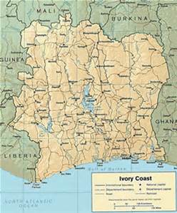
IVORY COAST


The Ivory Coast was a colony of France. The country official name is Cote
d'Ivoire. It is one of the most prosperous West Africa countries.

The landscape copies Ghana with rain forest in the south and high grassy plains in the north.


The hot, steamy south was covered with forest but it was cut down to make way for coffee and cocoa plantations.


Many wild animals live on the northern plateau such as lions, monkeys, antelopes and elephants. There is also grazing for cattle.


Two-thirds of the people living there are growing food like maize, rice and jams. Crops for export are grown and Ivory Coast is one of the world's largest coffee and cocoa producers.


Industry
Younger generation are working in factories in the old capital and chief port,
Aidjan. Half of the population is under 20 years old. Flour mills food canneries, breweries, sawmills, textile and plastics manufacturers are all thriving.

Since 1980 there is a prosperity boost from an offshore oil extracted from the Gulf of Guinea.


History

From 1893 to 1960 the French ruled the country. It became independent under the presidency of Felix
Houphouet-Boigny. He remained till his death in December 1993.

His policies were  - keep close ties with France; allowing plenty of foreign investment and keeping tribal rivalries under control.


ABIDJAN

 One of his major acts were to move the capital from Abidjan, known as the Paris of Africa, to his home village of Yamoussoukro.


YAMOUSSOUKRO CITY


The Ivory Coast republic has a population of 13 million and an area of 322,463 sq km. The religion is Muslim, Christian and Traditional.


 BASILICA OF OUR LADY OF PEACE

A Basilica of Our Lady of Peace was built in the capital and it is the  biggest church in the world. It is modelled on St Peter in Rome and completed in 1989.

Saturday, 26 November 2016

YEMEN


On the tip of the Arabian peninsula. Yemen is a large country. It is just smaller than France but two-thirds of it is uninhabited.


Yemen borders in the west by the Red Sea; on the north by Saudi Arabia; on the East by Oman and on the south by the Gulf of Aden.


In the west lies a wide coastal strip the
Tihama along a range of mountains. The highest peak Jaban an-Nabi Shu'ayh is 3700m. Behind the mountains lies a fertile high plateaux. In the middle of it is the capital San'a at an altitude of 2250m.

In these highlands are active volcanoes with hot springs and some times earthquakes.


The lower mountains towards Oman, in the east, are only 1000m high.


In the north the southern end of the Arabian Desert riches into Yemen till the middle of it.


AGRICULTURE
Yemen has twice a year a monsoon coming from the south. It make the country the most arable spot on the Arabian peninsula. The temperature various between regions and seasons.

Tihama and the southern coast are hot and with high humidity and a daytime temperatures topping 40C in summer.

Yemen cultivated so much land that little natural vegetation remain. In Tihama there are mangroves, salt-resistant plants pm the seashore and sparse grasses and shrubs on the dune valleys.

Inland, around the wadis and in the mountain foothills, the land is moist enough for evergreen plants growing, including palms and acacias.


Hunting had killed off most of the wild animals. There were leopards, gazelles, hyenas and jackals in southern Yemen.


TRIBAL LIFE
Yemen is a tribal society and the tribes are joined in 'federation'. Most people live in houses built of natural material. on the plains and around wadis, building materials are mud, brick and reeds.

Mountain houses are mostly build with stones.

RELIGION
The state religion is Islam while in the south are mostly Sunni Muslims and in the north are Shi'a sect. There was a minority of Jews but when the Israel was established in 1948 the majority left.

Yemen is a developing country with little industry. The majority is agriculture with most of the crops for its people.


Tropical fruit is grown on low level. At the middle level cereal is grown and at high level are coffee and
qat grown to export. On the central highlands sorghum , vegetables and spices are grown.


OIL ECONOMY
Oil was discovered in Marib in late 1980 but the output is low. The Yemen economy was mainly supported by its people working in oil-rich Gulf states.

In October 1990, Saudi
Arabia expelled over 1 million Yemenis because the country would support during the Gulf war. Most Arab countries and USA stopped economic aid and co-operation which a devastating impact.

HISTORY
Yemen used to be split into North and South Yemen. The North was ruled by an Imam, a religious leader, but was overthrown by a revolution.  Civil war continued until the 1970 when religious leaders agreed to a republican government run by the military. The country was renamed the Yemen Arab Republic (YAR).

Both north and south Yemen wanted to be reunited but the official relations between were bad.
In 1980, The
PDRY soften on its hard-line Marxist beliefs and better relation ship with YAR followed.

In 1990 unification was declared. The first free election  in the whole Arabian peninsula were held in April 1993 and a coalition government was formed between the three major parties.


YEMEN'S CAPITAL SAN'A

Friday, 11 November 2016

INDIA PART TWO


RESOURCES AND INDUSTRY
India is rich in minerals, with large deposits of coal, iron ore, oil, bauxite and zinc. The mining industry has progressed during the last decades but India is still not making full use of its huge mineral resources.

India has still rich tradition of crafts.

Manufacturing has increased since it started a series of a five-year economy development plans in 1951. Factories produce now cars, sewing machines, aircraft, textiles, railway engines and ships. The biggest bicycle factory in the world is Hero Cycles of Punjab.

India has the world's largest film industry much bigger than Hollywood. It has the nickname Bollywood because it was started in Bombay (Mumbay). It produces 700 films a year in 16 languages.

India is an independent federal republic and the largest democracy in the world. It is divided into 25 states and seven union territories. Each state has his own elected assembly and government.

The president of the republic heads the national government in New Delhi but is mainly a figurehead. Decision and the law is made in the lower house (Lok Sabha). The prime minister is usual the leader of the main party.

SUCCESSION OF EMPIRES
Ashoka in 3rd century BC united India but the Empire blossomed during the 4th century AD with Gupta.

PALACE IN JAIPUR

JODHPUR  PALACE

Then the Muslim empire followed and reached its height under Mughal emperors such as Akbar and Shah Jahan.


When the Mughal power declined Europeans went in and establish the East India Company in 1857. Revolt broke out and the British Government took over.


BOMBAY GATEWAY
WHERE BRITISH ALWAYS LANDED


It started the independent movement and under Mahatma Gandhi rapidly increased until 1947 India became independent. After Gandhi was assassinated Pakistan and Bangladesh split away.

Ever since India has dramatically improved economically and politically. India and Pakistan had also several wars.

ELECTIONS
Elections involves huge numbers of voters, voting stations and parties. In view of over 900 millions people living in India it is not surprising.

In 1991 there were over 314million people voting in the General Election; 359 parties to vote for; 565,000 polling station were needed and manned  by three million staff. 

INDIA PART ONE


India is the largest democracy. The country has great contrasts. It has nuclear power and satellite communications network yet most of the people's lives has not change  for century.

India is the seventh largest country by area. and only China has more than its 900 million people.

Its shape is a giant triangle jutting out into the Indian Ocean. Across the north are the Himalayas with some of the highest peak in the world. At the south of the Himalayas spreads across the country a broad and fertile land.

From Kashmir to the most southern tip, the cape Comoran, it is nearly 3000km.

There are many great rivers like the Ganges, the Brahmaputra, and several tributaries such as the Indus, flow across the northern plain and add to India's most fertile land.

A huge plateau in the south called the Deccan runs from the Arabian Gulf to the Bay of Bengal.

CLIMATE
Mountain areas in the north have a cool climate in summer and freezing temperatures in winter. The rest of northern India is very hot in summer. Temperatures can rich 48oC (120oF). The heat during the day is so intense people die of sunstroke. It last until the monsoon or the rainy season arrives.
Monsoons start on the cost in June and spreads across the north in July and August. In some parts this follows by a mild winter. but in the north. In Punjab and Bihar it can fall to freezing at night. The south and east has a humid climate for most of the year.

The Shillong plateau, just north of Bangladesh, is the second rainiest place in the world with 1.143cm (450 inches) a year. It is an important tea growing region.

LANGUAGES AND RELIGIONS
India has officially 16 languages and hundreds of locally spoken ones and over thousand dialects.

Children speak one language at home and become fluent in several more at school.

Hindi is the national language but many people in the south do not like to use it. English is often used at an official level.

The majority of Indians follow Hinduism. It is an ancient religion introduced by the Aryans nearly 3500 years ago. The river Ganges is sacred to Hindus, and many bathe in its waters at Varanasi.
There are also large numbers of Muslims, Christians, Sikhs, Jains and Buddhist.

The majority of Indians live in villages and most of them are very poor. They mostly work on the land but villages have a carpenter, shopkeeper and potter.

Wheat is the main crop in the northern plains while rice is mostly grown in the south. As well as rice, wheat. maize, millet and many other vegetables are grown there. India is one of the world largest producers of bananas, groundnuts, lentils, sugar cane, pepper, tea, coffee and cotton and jute for textiles.

India has the fourth largest railway network in the world with 62,000km of track. In some places it is still the only reliable transport since the roads are badly maintained. Most of the passenger trains are diesel and some electric.

There are still a great number of steam engines used and a joy to see for railway enthusiasts. They still run a incredible number of steam engines and all in immaculate conditions. Another remarkable point; they arrive dead on time even they have been travelling for 24 or even 48 hours. India has three class system. To travel in the first class is an absolute, enjoyable and affordable luxury.


It is incredible to us but it is India and its complete different way of live.


Thursday, 13 October 2016

AUSTRIAN SKI RESORT NEWS


The famous Austrian ski resorts Lech, Zuerch, Stuben and St Anton open their on-piste link this December.

It will make the Arlberg one of the biggest ski resorts in world. There are an unbelievable 82 lifts and 305km of pistes. It also promises no  queues.


ST ANTON AM ARLBERG

ST ANTON

Ski lifts are getting bigger, longer, faster and more comfortable.

The improvement of the ski resorts adds more hotels, chalets to be open in Decembers with a wide variety of styles.


LECH AUSTRIA

 If you would like to have a good time on a reasonable low budget book private  but book early because they are quickly taken.  You will get beautiful rooms with showers, a family, friendly service including a rich  breakfast. 

British Airways now flies from Heathrow direct to Innsbruck at a low price.